I would like to automaticaly identify shadows on Landsat scene in mountaineus area using Hillshade Tool (ArcGIS 10.1). I have
- 1 Landsat image from one date
- DEM (SRTM) from the same area
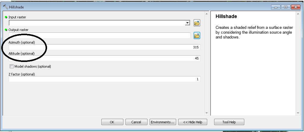
To create Hillshade raster (ArcGIS-> Tools-> Spatial analysis -> Surface -> Hillshade) I have to insert DEM and two characteristics of actual sun position:
 I
I
I have to input Azimuth and Altitude, relevant to actual sun position. In ESRI (http://resources.arcgis.com/en/help/main/10.1/index.html#//009z000000z2000000) help I can find this information:
- The azimuth is the angular direction of the sun, measured from north in clockwise degrees from 0 to 360. An azimuth of 90º is east. The default azimuth is 315º (NW).
- The altitude is the slope or angle of the illumination source above the horizon. The units are in degrees, from 0 (on the horizon) to 90 (overhead). The default is 45 degrees.
In different help (http://landtrustgis.org/technology/advanced/shaded%20relief) I can find information that I have to "Play with these values until you find a combination that yields reasonable, legible, and attractive results (a good starting point is altitude=45, azimuth=315)."
My question is, if it is possible to use Hillshade tool to exclude hillshades from Landsat scene?
For my Landsat image I have a specific DOY (Day of Year), can´t I directly convert this DOY information in Azimuth and Altitude values?
I suppose these values are relevant to the time of day but I think I can find this information somewhere on NASA web site (hour of Landsat data acquisition, not only the date).
Find shadows on Landsat image using DEM hillshade (by ArcGIS Hillshade Tool) 
Thanks for every recommendation