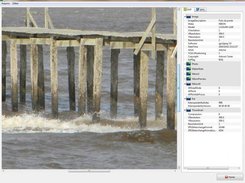
This software inserts and remove the tags exif latitude, longitude and altitude in jpeg, tiff and png images performing the geo-positioning of images, it uses tracklogs of GPS devices.
Features
- Handles tags EXIF / IPTC in images: jpeg, png, tiff, pgf, psd.
- Add latitude, longitude and altitude to images files.
- Remove latitude, longitude and altitude from images files.
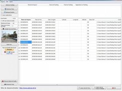
- Positioning geographically imagens using tracklogs GPS.
- Show all EXIF, IPTC and XMP informations.
Project Samples
Categories
Metadata EditorsLicense
GNU General Public License version 3.0 (GPLv3)Follow gps2jpeg
Other Useful Business Software
Catch Bugs Before Your Customers Do
Move from alert to fix before users notice. AppSignal monitors errors, performance bottlenecks, host health, and uptime—all from one dashboard. Instant notifications on deployments, anomaly triggers for memory spikes or error surges, and seamless log management. Works out of the box with Rails, Django, Express, Phoenix, Next.js, and dozens more. Starts at $23/month with no hidden fees.
Rate This Project
Login To Rate This Project User Reviews
Be the first to post a review of gps2jpeg!

