Опис
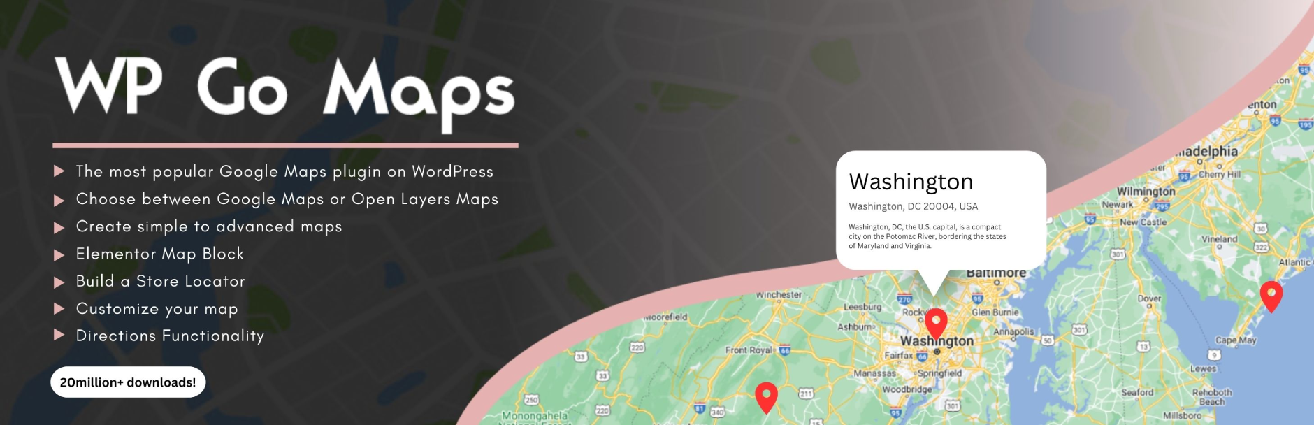
The easiest to use Google Maps, Leaflet and Open Layers Map Plugin (including a Map Block)!
Add a customized Google map, map block or Store Locator to your WordPress posts and/or pages quickly and easily with the supplied shortcode. No fuss. No iFrames and super easy to use! Perfect for contact page maps, routes, maps showing delivery areas and any other use you can think of!
While the free version of WP Go Maps allows you to create a Google map with as many markers as you like, the Pro version allows you to do so much more!
Create Elementor Maps, map blocks and map widgets easily with our WP Go Maps Elementor map block integration, straight out the box!
Do you use the classic editor? We still support map widgets for classic WordPress installations. No need to compromise, the map widget includes the same functionality as our map blocks!
The WP Go Maps Pro Version version allows you create custom Google maps with high quality markers containing locations, descriptions, images, categories, links and directions.
Lite версія (безкоштовно)
- Найпопулярніший плагін для Карт Google на WordPress
- Choose between Google Maps, Leaflet, Azure Maps, Stadia Maps, Maptiler, LocationIQ, Zero Cost or Open Layers Maps
- Супер проста у використанні, не вимагає кодування!
- Створіть стільки маркерів карти, скільки вам потрібно, просто введіть адресу
- Відповідні карти
- Elementor Map block
- Відредагуйте свої маркери карти одним натисканням кнопки
- 9 популярних тем на карті на вибір
- Створіть або додайте власну тему карти
- Перетягніть маркери карти до точного місцезнаходження
- Add a map block to your page
- Карти Google Streetview підтримуються
- Підтримка символів UTF-8
- Функція віджета карти
- Функціональність карти на весь екран
- Підтримка локалізації
- Виберіть один із чотирьох типів карт Google: дорожня карта, місцевість, супутник та гібрид
- Визначте власну ширину, висоту та масштабування для своєї карти
- Додайте анімацію до маркерів карти!
- Магазин функціональності локатора
- Обмежити пошук локатора магазинів по країні
- Додайте багатокутники до своєї карти
- Додати полілінії / маршрути на карту
- Створіть карту менше ніж за 30 секунд!
- Клацніть правою кнопкою миші, щоб додати маркер до вашої карти
- Немає реклами або посилань
- Автозаповнення Карт Google
- Транспортний шар Google Maps
- Встановіть максимальний рівень масштабування для вашої карти
- Подавати маркер на карті через вашу базу даних або файл XML
- Сумісність з плагінами кешування
- Сумісність з Cloudfare
- Останні API Карт Google
- Останній API OpenLayers
- Latest Leaflet API
Професійне видання
- Створити кілька карт!
- Дозвольте відвідувачам отримувати маршрути до своїх маркерів.
- Додайте описи, посилання та зображення до маркерів карти.
- Додайте категорії до маркерів карти
- Маркери фільтрів за категоріями
- Машуп кілька карт
- Advanced map blocks
- Store locator map block
- Directions map block
- Infowindow block
- Map block (filter)
- Додайте різні піктограми маркера або власні значки, щоб зробити вашу карту дійсно виділеною!
- Перерахуйте маркери на карту чотирма способами; основний список, основний стіл, карусель, розширений стіл
- Дозволити відвідувачам використовувати місце розташування карти як початкову або кінцеву точку для вказівки
- Виберіть між Карткою Інфо Індії та Карткою Карти Google
- Експортуйте / імпортуйте маркери у файл CSV для швидкого редагування.
- Посилання Fusion таблиці на ваші Карти Google
- Покажіть місцезнаходження вашого відвідувача на Карті
- Імпортуйте файли KML / KMZ на карту
- Більш розширені параметри для магазину
- Дозволити користувачам використовувати своє місце розташування карти для локатора магазину
- Пошук локаторів за категоріями
- Приховати всі маркери карти, доки пошуковий пошук локатора магазину не буде завершено
- Перемістіть список маркерів у вікні карти
- Кілька функцій віджетів карти
- Додайте піктограми маркера для карт із сітківкою
- WordPress Мережа дружня
- Get the WP Go Maps Professional Edition
Переклади
Get a free copy of the WP Go Maps Pro version in exchange for translating our plugin!
- Англійська – за замовчуванням
- Російська (Олександра Бондарева)
- Німецька
- Французька (Арно Томас)
- Польський (Міхал Котновський)
- Фінська (Johanna Joutti)
- Голландська (Ян Вітер)
- Іврит
- Датська (Патрік Джепсен)
- Італійська (Томмасо Морі та Масімо Брегані)
- Хорватська
- Грецький (Константінос Коукулакіс)
- Румунська (Cosmin Stroe)
- Іспанська (Кармело Віллегас Круз)
- Португальська (Хосе Антоніо Рібейро)
- Бразильський португальський (Роберто Коста)
- Турецька (Suha Karalar)
- Шведський (Мартін Сліпнер)
- Болгар (Любомир Колев)
- Індонезійська (Нено)
- Литовська
- Чехословацький^
^Мовний файл потрібно оновити
Демо-версії
WP Go Maps Lite
- Basic Google Map with Markers
- Store Locator
- Polygons & Polyines/Routes
- Google Maps Transit Layer
- Google Maps Traffic Layer
- Google Maps Bicycle Layer
WP Go Maps Pro
- Google map with advanced markers
- Marker listings – Simple
- Marker listings – Advanced
- Google Maps Directions
- Responsive Map
- Marker Categories (Filtering)
- Advanced Store Locator
- WP Go Maps Editor (Back-end Screenshots)
- Visitor Generated Markers – (WP Go Maps VGM Add-on)
- Custom Map Styling (WP Go Maps Gold Add-on)
Документація
- Installing WP Go Maps
- Creating your first map
- Adding a map block to your page or post
- Google Maps mashup (Pro)
- Exporting and importing map markers (Pro)
- Changing the Google Maps language
- Create a google map and marker using custom fields (Pro)
- View all documentation
Усунення неполадок
Скріншоти

The “Lite” version of WP Go Maps. 
The “Pro” version of WP Go Maps. 
WP Go Maps Pro version: Users can get directions to your map markers 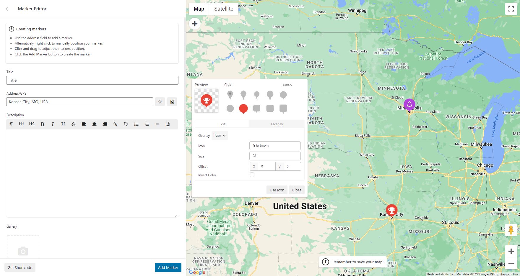
WP Go Maps Pro version: Add custom markers to your Google map 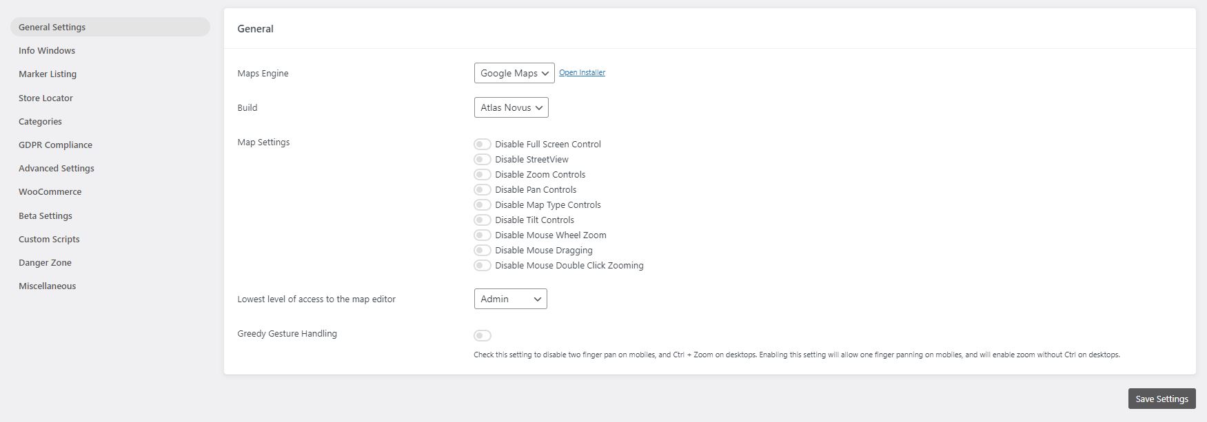
WP Go Maps Lite version: General settings page 
WP Go Maps Pro version: General settings page 
WP Go Maps Pro version: InfoWindow settings page 
WP Go Maps Pro version: Advanced Google map options. 
WP Go Maps Pro version: Map marker listing options 
WP Go Maps Pro version: Export/Import your map markers 
WP Go Maps Pro version: Responsive carousel map marker listing 
WP Go Maps Lite version: Store Locator Settings 
WP Go Maps Lite version: Store Locator Map 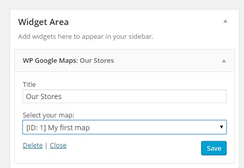
WP Go Maps Lite version: Map Widget 
Виберіть тему для вашої карти або виберіть тему з нашої тематичної бібліотеки
Блоки
Цей плагін надає 2 блоки.
- Map The easiest to use Google Maps plugin! Create custom Google Maps with high quality markers containing locations, descriptions, images and links. Add your customized map to your WordPress posts and/or pages quickly and easily with the supplied shortcode. No fuss.
- Store Locator WP Go Maps Store Locator block, allowing to separate your store locator from your map
Встановлення
First time WP Go Maps user
Thank you for choosing WP Go Maps! In order to create your Google map, simply activate the plugin and click on “Maps” in your left navigation menu.
Once the WP Go Maps page loads, set the options for your map (height, width, map type, zoom level etc) and then use your mouse to drag your Google map to your desired location and press the “Save map” button.
Copy and paste the shortcode into your post or page and WP Go Maps will automatically create the map on your page using the settings you chose above.
Додавання першого маркера карти
To add a marker to your Google map, scroll to below the map in your admin section and enter the address or GPS location in the Address input field. Click “Add Marker” and WP Go Maps will add your marker to the address you specified.
Налаштування Google Maps Store Locator
In order to make use of WP Go Maps Store Locator functionality, simply click on the “Store Locator” tab in the map creation page and select “Yes”
Часті питання
-
How do I get WP Go Maps Pro?
-
Simply visit https://www.wpgmaps.com and purchase the WP Go Maps Professional Edition. Free updates and support included forever.
-
Я встановив плагін, тепер що?
-
Once installed and activated, a link should appear in your left navigation panel within your WP-ADMIN section. Click on the “WP Go Maps” link and follow the on screen instructions.
-
Як мені помістити карту Google на мою сторінку / публікацію?
-
In order to show your custom Google map on your page or post, simply copy the shortcode supplied and paste it into your page or post. WP Go Maps will automatically configure the map to the settings you selected in the map edit page.
-
How do I add a map block to my page or post?
-
It’s super easy to add a map block to your page or post. Simply add a block in the normal page editor, then type in “Map” and you should see the map block option. For more information please review this tutorial
-
Як додати віджет карти до мого віджета?
-
To add your map to your widgets area, simply go to Appearance->Widgets and drag the “WP Go Maps” Map Widget to your sidebar. You then edit the map widget to reflect the correct map.
-
How can I report security bugs?
-
You can report security bugs through the Patchstack Vulnerability Disclosure Program. The Patchstack team help validate, triage and handle any security vulnerabilities. Report a security vulnerability.
Відгуки
Учасники та розробники
“WP Go Maps (formerly WP Google Maps)” — проект з відкритим вихідним кодом. В розвиток плагіну внесли свій вклад наступні учасники:
Учасники“WP Go Maps (formerly WP Google Maps)” було перекладено на 23 локалізації. Дякуємо перекладачам за їх роботу.
Перекладіть “WP Go Maps (formerly WP Google Maps)” на вашу мову.
Цікавитесь розробкою?
Перегляньте код, перегляньте сховище SVN або підпишіться на журнал розробки за допомогою RSS.
Журнал змін
10.0.02 – 2025-11-17
- Added shapes and overlays sub-section to map editor, moving all relevant datasets into that panel (UX Improvement)
- Added ability to click on a map from the map list to open the editor (UX Improvement)
- Added primary button color to edit map button within map list (UX Improvement)
- Added blue highlight to primary dataset creation buttons to make it clearer how to add datasets (UX Improvement)
- Added button to marker quick tip notice to jump straight to marker creation (UX Improvement)
- Added conditional checks for major version mismatches in compiler, preventing mismatched major versions from throwing build errors
- Added a one time hint tool to our internal map editor tour system, which will show helpful usage hints after the main tour is completed.
- Fixed issue where Google Maps logo would not display on some installations, within the engine selector
- Fixed issue where plugins that load bootstrap in our editor might cause editor placement issues, plugin conflict
- Fixed issue where map preview would not generate on some themes. We now generate a draft page, which is reused and pruned when new previews are created
- Moved save map notice in map editor to top anchor
- Moved add marker quick tip notice in map editor to bottom left anchor
- Removed bounds reset system when adding a marker to a map, to allow multiple markers to be added to the same region without reset
10.0.01 – 2025-11-10
- Fixed issue with compatibility layer for older versions of Pro add-on (V8 and below)
10.0.00 – 2025-11-10
- Added Leaflet engine support
- Added Azure engine, powered by Leaflet
- Added Stadia engine, powered by Leaflet
- Added Maptiler engine, powered by Leaflet
- Added LocationIQ engine, powered by Leaflet
- Added support for OpenLayers V10
- Added ability to use legacy (V6) OpenLayers, should be considered deprecated. Will be removed in the future
- Added ability to change address providers, for autocomplete and client side geocoding
- Added additional address providers including Google Maps, Azure Maps, Nominatim, LocationIQ and engine default
- Added ability to provide a supplementary address provider API key if needed
- Added ability to switch tile servers, with another from the same provider, on a per map basis
- Added additional tile server options, with providers and automated groupings
- Added ability to set line thickness on both rectangles and circles
- Added tile server previews for improved customization
- Added support for dynamic content translations with WPML
- Added Atlas Novus as the default internal build
- Added danger zone tool to reindex any spatial coordinate data for markers, where a spatial coordinate has gone missing
- Added ability to adjust rectangle boundaries with boundary input
- Added ability to bulk delete shapes
- Added ability to center on shapes and datasets within the editor
- Added dropdown context meny to shape datatables
- Added option to cachebust REST API requests
- Added improved GDPR styling, it becomes the new default
- Added quick delete button to info-window within the map editor
- Added ability to override any HTML template part via a child theme override
- Added map preview system, allowing maps to be previewed on frontpage
- Added default indexes to all tables to improve performance
- Added spatial indexes to tables where applicable to improve performance
- Added fullscreen map editor panel mode, for dataset listings, allowing more data to be viewed
- Added extended maximum zoom level (22) which is supported by all map engines
- Added mobile settings tab to editor
- Added ability to set a different map width/height for mobile devices
- Added new default engine/installer preset for zero cost mapping, for all new installations
- Added ability to reduce marker editor geocoder usage. Skips geocoding if lat/lng coordinates are present, opt in available in settings
- Added ability to select store locator button style (Icons (default), or Text) on a per map basis
- Added accessibility support, with the goal of being WCAG Level AA compliant
-
- Aria labels and roles added where needed
-
- Improved focus cues and managing of indexing
-
- Keyboard navigation added (tab, enter, space, and escape for panels)
-
- Hierarchy restructuring where needed to better support navigation
-
- Tested with various tools:
-
-
- Microsoft Accessibility Insights: Pass (FastPass)
-
-
-
- Axe DevTools: Pass (WCAG Level AA)
-
-
-
- Google Lighthouse: Pass (100% Accessible)
-
-
-
- Wave Tools: Pass
-
-
- Manual testing completed for navigation with a keyboard
-
- We will continue to improve this over time
-
- Known Issues
-
-
- Only supported on the frontend
-
-
-
- Does not allow marker selection via the map container (Marker listings supported, and encouraged for accessibility focused installations)
-
-
-
- Although a substantial rework has been implemented, this has not been verified by 3rd party compliance testers at this stage
-
-
-
-
- We know that accessibility is more nuanced than simple machine driven tests, we’d like to work with our community to ensure we improve this further
-
-
-
-
-
- Please reach out to us if you find anything that you feel should be improved as a priority!
-
-
- Improved internal autocomplete modules for better user experience and management
- Improved theme preset user interface
- Improved theme CSS editor
- Improved tile server system to handle params and authentication more efficiently
- Improved tile server system to properly attribute various service providers
- Improved settings user interface, adding sections and descriptors for better clarity
- Improved Google Maps Advanced Marker render mode support
- Improved Google Async support
- Improved zoom sliders within editor
- Improved map initialization state control
- Improved map initialization error correction
- Improved map initialization automatic delayed retry module
- Improved info-window open calls to include data-props in container for styling
- Improved styling system to allow native info-windows to inherit brand styling
- Improved open layers native info-window, now includes border radius and shadows
- Improved checkbox styling within the map viewport
- Improved available WP filters within our AjaxTable class, allowing count values to be filtered
- Improved internal shape architecture
- Improved batch loader logic and modularized method
- Improved welcome page to include new features
- Improved all option management by disabling autoloading, reducing impact on server resources
- Improved Legacy to Atlas Novus migration flow by introducing automatic map settings migration modules
- Improved DomDocument param handlers where needed
- Fixed issue where marker labels would not render & symbols correctly
- Fixed issue where major version mismatch would cause UI error to be thrown in REST API requests
- Fixed issue where shape datatables within the editor couldn’t be searched fully
- Fixed issue where touch events would not dispatch on OpenLayers shapes
- Fixed issue with error suppression in DomDocument class, added LIBXML_NOERROR when
- Fixed issue where some overlays would overlap info-windows in Open Layers (Example clusters)
- Fixed issue with clustering translations in DE language files
- Fixed issue where engine switch notice would show even if the user has already switched to Atlas Novus (manually)
- Moved build selection Danger Zone
- Moved optimization options out of beta
- Moved map mobile zoom level control to mobile panel section
- Removed Stamen Design tile servers, as they have moved to Stadia
- Removed OpenPtMap tile server due to missing SSL
- Removed duplicate map fetch methods, which were unused
- Archived V9 changelogs
For more, please view the WP Go Maps site