
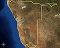
Category:Satellite pictures of Namibia

Countries of Africa: Algeria · Angola · Benin · Botswana · Burkina Faso · Burundi · Cameroon · Cape Verde · Central African Republic · Chad · Comoros · Democratic Republic of the Congo · Republic of the Congo · Djibouti · Egypt‡ · Equatorial Guinea · Eritrea · Eswatini · Ethiopia · Gabon · The Gambia · Ghana · Guinea · Guinea-Bissau · Ivory Coast · Kenya · Lesotho · Liberia · Libya · Madagascar · Malawi · Mali · Mauritania · Mauritius · Morocco · Mozambique · Namibia · Niger · Nigeria · Rwanda · São Tomé and Príncipe · Senegal · Seychelles · Sierra Leone · Somalia · South Africa · South Sudan · Sudan · Tanzania · Togo · Tunisia · Uganda · Zambia · Zimbabwe
Limited recognition: Somaliland – Other areas: Canary Islands · Ceuta · Madeira · Mayotte · Melilla · Réunion · Saint Helena, Ascension and Tristan da Cunha · Western Sahara
‡: partly located in Africa
Limited recognition: Somaliland – Other areas: Canary Islands · Ceuta · Madeira · Mayotte · Melilla · Réunion · Saint Helena, Ascension and Tristan da Cunha · Western Sahara
‡: partly located in Africa
Subcategories
This category has the following 6 subcategories, out of 6 total.
B
I
L
S
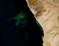
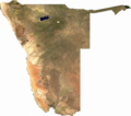
Media in category "Satellite pictures of Namibia"
The following 95 files are in this category, out of 95 total.
-
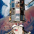 1990 s32 LDEF and Columbia over Namibia.jpg 1,840 × 1,807; 1.67 MB
-
.jpg/120px-Bloom_off_Namibia_(MODIS_2025-03-12).jpg) Bloom off Namibia (MODIS 2025-03-12).jpg 2,538 × 1,919; 454 KB
Bloom off Namibia (MODIS 2025-03-12).jpg 2,538 × 1,919; 454 KB
-
.jpg/120px-Bloom_off_of_Namibia_(MODIS).jpg) Bloom off of Namibia (MODIS).jpg 2,778 × 2,165; 349 KB
Bloom off of Namibia (MODIS).jpg 2,778 × 2,165; 349 KB
-
 Brand hires trimmed.jpg 1,128 × 1,128; 1.56 MB
-
 Brand hires.jpg 1,224 × 1,318; 1.58 MB
-
.jpg/120px-Brandberg_massif_(ASTER).jpg) Brandberg massif (ASTER).jpg 1,056 × 368; 75 KB
Brandberg massif (ASTER).jpg 1,056 × 368; 75 KB
-
 Brandberg Massif Landsat Image.jpg 1,000 × 1,000; 215 KB
-
 Brandberg Mountain SPOT 1350.jpg 500 × 500; 102 KB
-
 Brukkaros Mountain, Namibia, March 9, 2020 SkySat.jpg 1,920 × 1,080; 494 KB
-
 Cercles des fées en Namibie vus par Sentinel-2.jpg 3,080 × 3,080; 8.61 MB
-
 Colourful Naukluft ESA359250.jpg 7,434 × 4,970; 58.09 MB
-
 Colourful Naukluft ESA359250.tiff 7,434 × 4,970; 73.76 MB
-
 Creativity of Mother Nature - 2.jpg 5,568 × 3,712; 3.57 MB
-
 Creativity of Mother Nature.jpg 5,568 × 3,712; 4.79 MB
-
 Cuando-Chobe 636X366.jpg 636 × 366; 45 KB
-
 Dust and Hydrogen Sulfide along the Namibian Coast.jpg 2,600 × 3,400; 729 KB
-
.jpg/120px-Dust_and_Salt_off_Coast_of_Nambia_(MODIS).jpg) Dust and Salt off Coast of Nambia (MODIS).jpg 4,333 × 3,410; 4.37 MB
Dust and Salt off Coast of Nambia (MODIS).jpg 4,333 × 3,410; 4.37 MB
-
.jpg/120px-Dust_off_Nambia_and_South_Africa_(MODIS_2021-06-05).jpg) Dust off Nambia and South Africa (MODIS 2021-06-05).jpg 5,495 × 4,809; 1.66 MB
Dust off Nambia and South Africa (MODIS 2021-06-05).jpg 5,495 × 4,809; 1.66 MB
-
.jpg/120px-Dust_off_Namibia_and_South_Africa_(MODIS_2020-06-18).jpg) Dust off Namibia and South Africa (MODIS 2020-06-18).jpg 3,691 × 2,980; 674 KB
Dust off Namibia and South Africa (MODIS 2020-06-18).jpg 3,691 × 2,980; 674 KB
-
.png/120px-Dust_storms_off_the_northern_coast_of_Namibia_(satellite_view_-_10_May_2000).png)
-
.jpg/120px-Earth_from_Space_Brandberg_Mountain,_Namib_Desert,_Namibia_(29293875655).jpg) Earth from Space Brandberg Mountain, Namib Desert, Namibia (29293875655).jpg 8,191 × 10,980; 42.84 MB
Earth from Space Brandberg Mountain, Namib Desert, Namibia (29293875655).jpg 8,191 × 10,980; 42.84 MB
-
 Envisat captures the Orange River ESA230174.jpg 3,189 × 2,557; 1.75 MB
-
 Etosha National Park, Namibia ESA207078.tiff 1,408 × 1,408; 5.81 MB
-
 Etosha National Park, Namibia.jpg 1,408 × 1,408; 1.51 MB
-
 Etosha Pan, Namibia - NASA Earth Observatory.jpg 720 × 720; 175 KB
-
 Etosha pan.jpeg 639 × 639; 113 KB
-
 EtoshaBorders.jpg 1,406 × 642; 276 KB
-
 EtoshaBordersThumb.jpg 486 × 219; 43 KB
-
.jpg/120px-EtoshaPan_2005_(cropped).jpg) EtoshaPan 2005 (cropped).jpg 536 × 351; 50 KB
EtoshaPan 2005 (cropped).jpg 536 × 351; 50 KB
-
 EtoshaPan 2005-06 comparison.jpg 540 × 782; 103 KB
-
 Etoshapan tmo 2019345 lrg.jpg 6,428 × 4,285; 2.54 MB
-
 Etoshapan tmo 2019345.jpg 720 × 480; 281 KB
-
 Etoshapan tmo 202017 lrg.jpg 6,428 × 4,285; 5.02 MB
-
 Etoshapan tmo 202017.jpg 720 × 480; 350 KB
-

-
 Hydrogen Sulfide Emissions off of Africa.jpg 1,295 × 870; 449 KB
-
 Iss069e086612.jpg 5,568 × 3,712; 2.35 MB
-
 Iss069e086680.jpg 4,928 × 2,768; 6.86 MB
-
 Kuiseb-Rainfall-thumb.jpg 300 × 218; 20 KB
-
 Kuiseb-Rainfall.jpg 1,279 × 928; 572 KB
-
 Kuiseb.jpg 1,280 × 930; 533 KB
-
.jpg/120px-Light_blue_and_green_waters_off_the_coast_of_Namibia_indicate_phytoplankton_bloom_(2268-354).jpg)
-
 Linear Dunes, Namib Sand Sea.jpg 720 × 480; 268 KB
-
 Lüderitz ISS011-E-9513.jpg 2,008 × 3,024; 1.01 MB
-
 Nambia-Landsat7.jpg 1,280 × 1,024; 428 KB
-
.jpg/120px-Nambian_Desert_(MODIS_2020-04-15).jpg) Nambian Desert (MODIS 2020-04-15).jpg 2,184 × 1,658; 285 KB
Nambian Desert (MODIS 2020-04-15).jpg 2,184 × 1,658; 285 KB
-
 Namib-Naukluft-Park-Borders-Sat.jpg 846 × 1,526; 343 KB
-
.jpg/120px-Namibia_(MODIS_2018-05-24).jpg) Namibia (MODIS 2018-05-24).jpg 1,753 × 1,494; 365 KB
Namibia (MODIS 2018-05-24).jpg 1,753 × 1,494; 365 KB
-
.jpg/120px-Namibia_(MODIS_2018-09-13).jpg) Namibia (MODIS 2018-09-13).jpg 1,984 × 1,321; 266 KB
Namibia (MODIS 2018-09-13).jpg 1,984 × 1,321; 266 KB
-
.jpg/120px-Namibia_(MODIS_2019-05-07).jpg) Namibia (MODIS 2019-05-07).jpg 1,897 × 1,420; 213 KB
Namibia (MODIS 2019-05-07).jpg 1,897 × 1,420; 213 KB
-
.jpg/120px-Namibia_(MODIS_2019-11-25).jpg) Namibia (MODIS 2019-11-25).jpg 2,547 × 2,009; 599 KB
Namibia (MODIS 2019-11-25).jpg 2,547 × 2,009; 599 KB
-
.jpg/120px-Namibia_2017_03_08_(32514208573).jpg) Namibia 2017 03 08 (32514208573).jpg 5,280 × 3,228; 2.7 MB
Namibia 2017 03 08 (32514208573).jpg 5,280 × 3,228; 2.7 MB
-
 Namibia AMO 2005221 lrg.jpg 1,800 × 1,400; 180 KB
-
 Namibia BMNG.png 2,058 × 1,917; 4.13 MB
-
.jpg/120px-Namibia_dunes_(ASTER).jpg) Namibia dunes (ASTER).jpg 3,900 × 3,308; 2.49 MB
Namibia dunes (ASTER).jpg 3,900 × 3,308; 2.49 MB
-
.jpg/120px-Namibia_Dunes_(ASTER).jpg) Namibia Dunes (ASTER).jpg 3,369 × 2,879; 2.43 MB
Namibia Dunes (ASTER).jpg 3,369 × 2,879; 2.43 MB
-
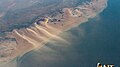
 Namibia is among the driest African nations ESA211512.jpg 1,241 × 1,241; 446 KB
-
 Namibia is among the driest African nations ESA211512.tiff 1,241 × 1,241; 7.81 MB
-
 Namibia may 11 2001 0920Z.jpg 3,600 × 4,800; 1.81 MB
-
 Namibia notbloom.jpg 375 × 370; 45 KB
-
 Namibia sat.png 1,626 × 1,443; 2.73 MB
-
 Namibia TMO 2006058 lrg.jpg 4,000 × 4,000; 3.51 MB
-
.jpg/120px-Namibia's_Orange_Desert_(MODIS_2024-06-06).jpg) Namibia's Orange Desert (MODIS 2024-06-06).jpg 1,530 × 1,091; 211 KB
Namibia's Orange Desert (MODIS 2024-06-06).jpg 1,530 × 1,091; 211 KB
-
.jpg/120px-Namibia,_Botswana,_and_South_Africa_(MODIS_2017-12-04).jpg) Namibia, Botswana, and South Africa (MODIS 2017-12-04).jpg 4,695 × 4,100; 1.89 MB
Namibia, Botswana, and South Africa (MODIS 2017-12-04).jpg 4,695 × 4,100; 1.89 MB
-
 Namibia’s Protected Coast.jpg 4,000 × 5,600; 4.27 MB
-
 Namibië satelliet.jpg 1,800 × 2,400; 537 KB
-
 NEO etosha big.jpeg 600 × 800; 93 KB
-
 NEO kuiseb.jpeg 540 × 304; 36 KB
-
 Omatako Mountains, Namibia.jpg 2,048 × 1,280; 906 KB
-
 Record-setting temperatures in South Africa, April 2021.jpg 3,617 × 2,457; 4.89 MB
-
 Rossing mine and vicinity 2013.jpg 720 × 720; 147 KB
-
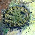
 Roter Kamm crater x2.jpg 1,122 × 597; 129 KB
-
 Roter Kamm crater.jpg 935 × 656; 106 KB
-
.jpeg/120px-Roter_Kamm_impact_crater_ESA22104135_(cropped).jpeg) Roter Kamm impact crater ESA22104135 (cropped).jpeg 218 × 225; 8 KB
Roter Kamm impact crater ESA22104135 (cropped).jpeg 218 × 225; 8 KB
-
 Roter Kamm impact crater ESA22104135.jpeg 2,717 × 2,717; 1.56 MB
-
 Roter Kamm, PIA00503 md.jpg 2,896 × 2,032; 3.87 MB
-
 Satellitenbild Rundu mit Umland.jpg 853 × 658; 136 KB
-
 Satellitenbild Tsumeb.jpg 801 × 771; 154 KB
-
 Satellitenbild Windhoek.jpg 784 × 910; 192 KB
-
.jpg/120px-SpaceX_CRS-14_Dragon_approaches_the_ISS_(1).jpg) SpaceX CRS-14 Dragon approaches the ISS (1).jpg 4,928 × 3,240; 1.93 MB
SpaceX CRS-14 Dragon approaches the ISS (1).jpg 4,928 × 3,240; 1.93 MB
-
 SpaceX CRS-14 Dragon released by Canadarm2.jpg 5,568 × 3,712; 1.69 MB
-
 Swirls of a plankton bloom captured by Envisat ESA204138.jpg 2,007 × 2,007; 1.37 MB
-
 Swirls of a plankton bloom captured by Envisat ESA204138.tiff 2,007 × 2,007; 9.2 MB
-
 Thermal signature of Namibian coastline ESA358134.jpg 1,453 × 1,325; 1.58 MB
-
 Tsauchab River taken from ISS 2009-12-24.jpg 1,440 × 960; 695 KB
-
.jpg/120px-Ugab_River,_Namibia_(ASTER).jpg) Ugab River, Namibia (ASTER).jpg 2,886 × 2,319; 1.73 MB
Ugab River, Namibia (ASTER).jpg 2,886 × 2,319; 1.73 MB
-
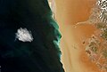
 Walvisbay-sat.jpg 690 × 928; 224 KB
-
 Waterberg Sat.jpg 400 × 300; 27 KB
-
 Wind Sand and Stars - 2.jpg 5,032 × 2,854; 3.89 MB
-
 Wind Sand and Stars.jpg 5,064 × 3,390; 4.73 MB
-
 WorldWind 2006-03-02 15-51-09-18.jpg 1,280 × 948; 122 KB
-
 WorldWind 2006-05-03 14-22-15-89.png 1,260 × 926; 1.68 MB
-
 Zambezi ali 2010128.jpg 719 × 480; 177 KB
-
.jpg/120px-Zambezi_Flood_Plain,_Namibia_(EO-1).jpg) Zambezi Flood Plain, Namibia (EO-1).jpg 4,200 × 2,800; 4.01 MB
Zambezi Flood Plain, Namibia (EO-1).jpg 4,200 × 2,800; 4.01 MB
-
 Zambia.A2004112.0845.721.250m.jpg 2,871 × 3,131; 4.58 MB