
Category:West Haifa
administrative district of Haifa, Israel   | |||||
| Upload media | |||||
| Instance of | |||||
|---|---|---|---|---|---|
| Location | Haifa, Haifa Subdistrict, Haifa District, Israel | ||||
| Area |
| ||||
 | |||||
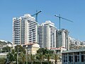
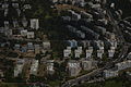
West Haifa is the long stretch of partially-urbanized coastline along the western slopes of Mount Carmel. Major places in this borough are Bat Galim-Kiryat Eliezer to the north, bordering Downtown; Neve David-Kiryat Sprinzak-Ein HaYam in the centre - separated from the water by a wide barrier consisting of the southbound railroad and Road 4, and the Southwest to the south.
Subcategories
This category has the following 14 subcategories, out of 14 total.
2
B
E
H
K
- Kiryat Sprinzak (9 F)
L
- Leonardo hotel, Haifa (37 F)
N
- Nahal Lotem (28 F)
O
P
- Pluri Inc. (2 F)
S
Media in category "West Haifa"
The following 18 files are in this category, out of 18 total.
-
.jpg/120px-Haifa_DSCN0493_(14177894492).jpg) Haifa DSCN0493 (14177894492).jpg 4,608 × 2,740; 1.1 MB
Haifa DSCN0493 (14177894492).jpg 4,608 × 2,740; 1.1 MB
-
 Haifa Views from W HaYam nr HaDolev 1 OIC.jpg 1,600 × 1,200; 700 KB
-
 Haifa Views from W HaYam nr HaDolev 2 OIC.jpg 1,600 × 1,200; 581 KB
-
 Israelmarka.jpg 2,304 × 1,728; 1.62 MB
-
 Ma'arav Haifa In Haifa.svg 483 × 394; 121 KB
-
 Ramat HaNasi.jpg 2,501 × 1,890; 784 KB
-
 St. Luke's school for boys. Haifa, israel.jpeg 2,376 × 1,256; 1.14 MB
-
 West Haifa.jpg 4,608 × 3,456; 5.21 MB
-
 Western Haifa from the air.jpg 1,371 × 957; 777 KB
-
 WikiAir Flight IL-13-02 1575.JPG 6,016 × 4,000; 10.47 MB
-
 WikiAir Flight IL-13-02 1580.JPG 6,016 × 4,000; 9.63 MB
-
 WikiAir Flight IL-13-02 1581.JPG 6,016 × 4,000; 9.24 MB
-
 WikiAir Flight IL-13-02 1582.JPG 6,016 × 4,000; 9.34 MB
-
 WikiAir Flight IL-13-02 1583.JPG 6,016 × 4,000; 11.54 MB
-
 WikiAir Flight IL-13-02 1591.JPG 6,016 × 4,000; 7.66 MB
-
.jpg/120px-מסגד_סיידנא_מחמוד_-_שכונת_כבביר_בחיפה_-_אתרי_מורשת_2016_(13).jpg) מסגד סיידנא מחמוד - שכונת כבביר בחיפה - אתרי מורשת 2016 (13).jpg 2,880 × 4,320; 4.15 MB
מסגד סיידנא מחמוד - שכונת כבביר בחיפה - אתרי מורשת 2016 (13).jpg 2,880 × 4,320; 4.15 MB
-
 נאות פרס בחיפה.jpg 2,652 × 1,989; 1.13 MB
-
 נאות פרס.jpg 1,548 × 871; 165 KB