
Seine
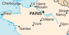
The Seine is a 777-kilometre-long (483 mi) river and an important commercial waterway within the Paris Basin in the north of France. It rises at Source-Seine, 30 kilometres (19 mi) northwest of Dijon in northeastern France in the Langres plateau, flowing through Paris and into the English Channel at Le Havre (and Honfleur).
Main category: Seine River
Map
[edit]Main category: Maps of Seine River


River source
[edit]Main category: Source of the Seine River


Île-de-France
[edit]Paris
[edit]Main category: Seine River in Paris
- Related Wikidata property: Paris, Seine in Paris
-
 The river Seine as seen from the top of the Eiffel Tower
 -
 The Seine.
 -
 The Seine seen from the Petit Pont near the Notre-Dame de Paris
 -
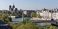
 The Seine with the Île de la Cité and the Île Saint-Louis
 -

-
 Statue der Seine auf der Pont du Carrousel
 -
 Dredging in the Seine river in Paris
 -
 View over the Seine in Paris, Pont des Invalides
 -
.jpg/120px-ISS063-E-21190_-_View_of_France_-_Seine_-_island_Île_Seguin_-_Meudon_-_Sèvres_-_Île_Monsieur_-_Boulogne-Billancourt_-_Île_Saint-Germain_(cropped).jpg) island Île Seguin, Sèvres, Meudon, Île Saint-Germain, Boulogne-Billancourt
island Île Seguin, Sèvres, Meudon, Île Saint-Germain, Boulogne-Billancourt
Normandy
[edit]
-
.JPG/120px-Bac_à_La_Bouille_(France).JPG) bac à La Bouille
bac à La Bouille -
 Pont Gustave Flaubert, Rouen
 -
 Caudebec-en-Caux, Normandy
 -
 Caudebec-en-Caux, Normandie
 -
 Villequier, Normandy
 -
 Bac de Jumièges
 -
 Pont de Normandie
 -
 the Seine estuary, Normandie, right bank
Estuary
[edit]Main category: Seine estuary
-
-

-
-
 Estuaire, Le Havre
Painting
[edit]Main category: Paintings of the Seine
-

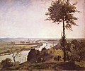
A Summer Day near Samois
(Theodor von Hörmann, 19th century) -
-
 Flood in Paris, 1910, by Carlo Brancaccio