UPDATE # 01 : Links to related past questions:
Mirrored Contours from DEM in QGIS
gdal_translate creates images that are mirrored
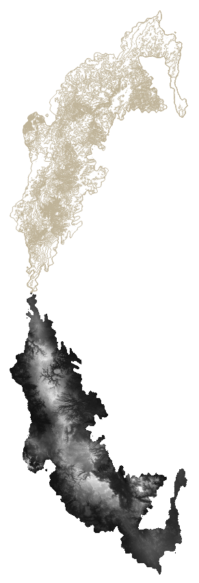
This question has been asked before, but I can't fix my personal issue, perhaps because the coordinate-less TIFF I'm using to produce my contour is one made up of bits of DEMs.
How can I have the contour appear exactly on top of my landmass?
GDAL command: gdalinfo -mm -stats D:/H09.tiff GDAL command output: Driver: GTiff/GeoTIFF Files: D:/H09.tiff Size is 2244, 3564 Metadata: TIFFTAG_DATETIME=2022:04:01 09:57:47 TIFFTAG_RESOLUTIONUNIT=2 (pixels/inch) TIFFTAG_XRESOLUTION=96 TIFFTAG_YRESOLUTION=96 Image Structure Metadata: COMPRESSION=DEFLATE INTERLEAVE=PIXEL PREDICTOR=2 Corner Coordinates: Upper Left ( 0.0, 0.0) Lower Left ( 0.0, 3564.0) Upper Right ( 2244.0, 0.0) Lower Right ( 2244.0, 3564.0) Center ( 1122.0, 1782.0) Band 1 Block=2244x1 Type=UInt16, ColorInterp=Gray Computed Min/Max=0.000,36355.000 Minimum=0.000, Maximum=36355.000, Mean=3509.658, StdDev=6167.460 Mask Flags: PER_DATASET ALPHA Metadata: STATISTICS_MAXIMUM=36355 STATISTICS_MEAN=3509.6577052462 STATISTICS_MINIMUM=0 STATISTICS_STDDEV=6167.4600463843 STATISTICS_VALID_PERCENT=100 Band 2 Block=2244x1 Type=UInt16, ColorInterp=Alpha Computed Min/Max=0.000,65535.000 Minimum=0.000, Maximum=65535.000, Mean=21887.963, StdDev=30885.667 Metadata: STATISTICS_MAXIMUM=65535 STATISTICS_MEAN=21887.962675002 STATISTICS_MINIMUM=0 STATISTICS_STDDEV=30885.666560733 STATISTICS_VALID_PERCENT=100 Process completed successfully Execution completed in 0.34 seconds