3

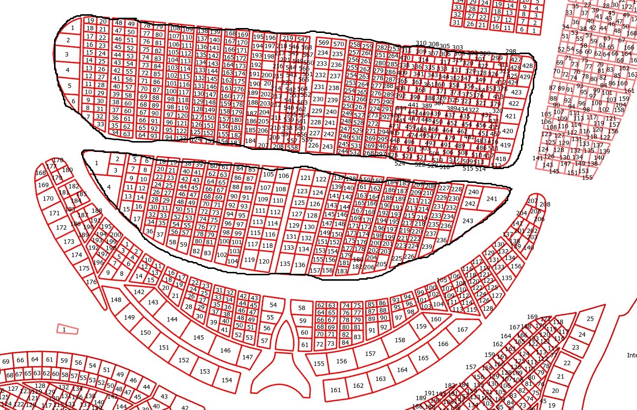
Using ArcGIS Pro, I am trying to dissolve cemetery plots into one main region. In the attached image, you can see that each section of the cemetery has multiple plots. I would like to dissolve each section so that it becomes one polygon, including the empty spaces between plots (The black line that is poorly drawn). Basically, I am looking for a tool that will take the outside most line of each section, and jump the gap of the walking paths, and encircle the entire section. Dissolve only removes the plot lines in each part.

Image

5
  • 1
    If you have an advance license try the aggregate polygons tool in the cartography toolbox. Remember tools honour selections. Commented Jan 2 at 17:47
  • 1
    Welcome to GIS SE. Thank you for taking the Tour. There are literally an infinite number of ways to do this, so tools have no way to know how you want it done. You need to decide the rules you will use to merge these shapes. Do you want a concave hull? A convex hull? Non-overlapping convex-ish hulls? Your graphic doesn't show what you want, so we can't tell you how to get there. Commented Jan 2 at 18:53
  • The 'Minimum Bounding Geometry' tool with the Convex Hull option would probably work for those two areas you indicated. But it would NOT work for some other areas (such as the crescent shaped area below them). You would need some sort of Concave Hull for this, which is much more difficult to do well (and requires a lot more guidance/rules). For information (and 3rd party tools), see: community.esri.com/t5/python-blog/… and community.esri.com/t5/arcgis-pro-ideas/… Commented Jan 2 at 22:16
  • Maybe try some buffer, dissolve, negative buffer distances? Commented Jan 3 at 9:44
  • The Aggregate Polygons did exactly what I was hoping. Screen Shot attached of the result. I just have to know what the largest distance is between polygons in order to include the entirety of the area in each section. !Solution Image Commented Jan 3 at 16:52

2 Answers 2

3

If you have access to an Advanced license, then Aggregate Polygons (Cartography) -ArcGIS Pro | Documentation as mentioned in the comments is probably the first tool to try. Aggregate Polygons works best when the areas you want to define share a common attribute beyond only being spatially close to each other.

Since no sample or example data was shared, a bitmap trace with a bit of cleanup created a representative data set (and a more challenging dataset since all of the plots are spatially disjointed from each other). Aggregate Polygon processed it in a couple minutes and gives the result you are after: enter image description here

If an Advanced license isn't available, the concavehull tool that is part of GitHub - Dan-Patterson/Tools_for_ArcGIS_Pro might be worth a try. The concavehull tool states it needs a point layer, but it works if you feed it a polygon layer: enter image description here

There are a few oddities to clean up, but it gets pretty close and likely better than trying to roll your own solution.

0

Assuming that roads/driveways are wider than foot paths between plots, extract plot vertices and generate near table with locations (experiment with number of nearest neighbours): enter image description here enter image description here

Convert XY table to lines and remove ones that are longer than widest estimate of footpath. Use feature to polygon (plots and lines) followed by dissolve. You'll get very close to target:

enter image description here

Start asking to get answers

Find the answer to your question by asking.

Ask question

Explore related questions

See similar questions with these tags.