Namibia
Presidential republic
Official:
Republic of Namibia
Local name:
Namibia
Region:
Southern Africa
Surface area:
824,290 km²
Capital:
Windhoek

Geography
Namibia is a country on the Altantic Coast of South Africa. The land has a total area of 824,290 km² (318,260 mi²) and a total coastline of 1,572 km (976.8 mi). This land area is approximately 118% of the area of Texas. Namibia is thus one of the largest countries in Africa and the 34th biggest in the world. With 3.7 inhabitants per km² it is one of the most sparsely populated countries on earth. More than half of all residents (50%) live within cities. Around one in six residents lives in Windhoek alone.Namibia is comparatively high at an average elevation of 1141 meters above sea level. The highest mountain peak (Königstein peak of Brandberg) is at 2,573 meters. The country has about 30 islands. There are direct national borders with the four neighboring countries Angola, Botswana, South Africa and Zambia. The distance between New York City and the Capital Windhoek is about 11,710 km (7,276 mi).
On further pages:
Current time in Namibia:
The countrywide time in Namibia is Central Africa Time (CAT), which is currently 6 hours ahead of New York. Daylight saving time has no longer been in use since September 2017. Related to Greenwich Mean Time, there's the same difference of 2 hours all over the year.
Sunrise + Sunset00:00
April 2026
The countrywide time in Namibia is Central Africa Time (CAT), which is currently 6 hours ahead of New York. Daylight saving time has no longer been in use since September 2017. Related to Greenwich Mean Time, there's the same difference of 2 hours all over the year.
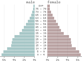
Population
Population:3,030,000
Population per km²:3.676
Life expectancy males:Ø 63.3 years
Life expectancy females:
Ø 71.3 yearsBirth rate:
25.9 ‰Death rate:
6.2 ‰Males/Females:
48.8% : 51.2%Population pyramid
The currency in Namibia is the Namibian dollar (NAD).
1 Dollar is divided into 100 Cents.
Status: 04/10/2026
1 Dollar is divided into 100 Cents.
Status: 04/10/2026
1 US dollar = 16.43 Dollars
100 Dollars = 6.09 US dollar
100 Dollars = 6.09 US dollar
Climate in Namibia
In Namibia, as in all equatorial countries, there is a tropical climate. Unlike in Europe or the USA, there is almost no difference between the seasons. The daylight hours vary little, and the temperature differences between summer and winter are also lower. Depending on the season, the average daytime temperatures range between 26 and 33 degrees. In some parts of the country, the temperature rises to 41 °C. In the colder months, and depending in the region, the temperature drops to 8 °C in a month's average.Average daytime and nighttime temperatures
🔍
Languages
| Mother tongue | Distribution |
|---|---|
| Ovambo | 48.9 % |
| Nama | 11.3 % |
| Afrikaans | 10.4 % |
| Herero | 8.6 % |
| Kavango | 8.5 % |
| Caprivi | 4.8 % |
| English | 3.4 % |
| San | 1.9 % |
| German | 0.9 % |
| other | 1.3 % |
Religions
| Religion | Distribution |
|---|---|
| Christs | 85.0% |
| Native religions | 14.0% |
| other | 1.0% |
Land use
| 0% Urban areas: | 2,468 km² |
| 47% Agricultural areas: | 388,570 km² |
| 8% Forest: | 66,438 km² |
| 0% Water areas: | 1,000 km² |
| 45% Others: | 365,814 km² |
more...
Transport
| Roadways: | 48,875 km |
| Railways: | 2,628 km |
| Reg. vehicles: | 418,292 |
| › Airports: | 30 |
more...
With an average annual income of 4,240 USD Namibia is one of the lower middle-income countries.
Economy
According to the definition from the International Monetary Fund (IMF), Namibia is a developing country because of its lower economic performance. There is one of the lowest crime rates in the world.With an average annual income of 4,240 USD Namibia is one of the lower middle-income countries.
| GDP: | 13.37 bn $ |
| Exportations: | 5,957.6 M $ |
| Importations: | 9,236.2 M $ |
| Tourism receipts: | 277.00 M $ |
| Debt rate: | 63.57 % |
| › Unemployment rate(ILOEST): | 19.29 % |
| › Inflation rate: | 3.90 % |
| › Corruption index: | 46 (bad) |
| › Energy consumption: | 3.9 bn kWh |
Existing trade agreements
Political indicators
(Based on the "Worldwide Governance Indicators" project of the World Bank)
| Political stability: | ◈ |
| Rule of law: | ◈ |
| Effectivity: | ◈ |
| Regulatory quality: | ◈ |
| Voice accountability: | ◈ |
| Autocracy Index: | ◈ |
| Death penalty: | abolished in 1990 |