3

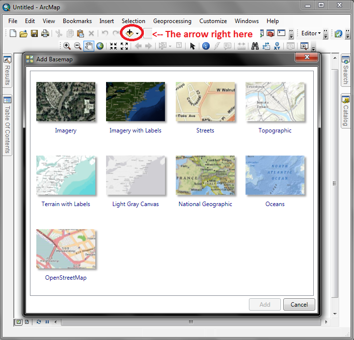
How can I add an external online map in ArcMap by inserting the http address, to use as a basemap in order to georeference multiple aerial photos?

I don't really care about the precision of the georeferencing. I just want to use the template as a quick-to-use index for the aerial photos.

1
  • 1
    Are your Greek Cadastre maps available as ArcGIS For Server map services and/or WMS and/or some other form of online maps? This is an important detail that seems to be missing from your Question so can you edit your question to include it, please? Commented Nov 11, 2013 at 4:47

1 Answer 1

11

Complimentary use of Bing maps is currently being phased out by Esri, and after December 31st, you'll no longer be able to use it at all. Right now, I think the only way you can use Bing as your basemap is if you have it in a map document that was saved before the cut-off date. See the blog post, Bing Maps Use in ArcMap Has Changed.

There are still free basemaps that you can use to georeference your data, though. Just press the little down arrow next to Add Data and you can select Add Basemap to select the one best fits your needs.enter image description here

5
  • Thanks for your answer! To be completely understood I want to use the online maps from the Greek Cadastre as a basemap and i was wondering if there is a way to insert the internet address of the maps and work on them. Commented Nov 10, 2013 at 20:23
  • @user23822, I don't know of a way to access outside maps like that; you should edit this information into your original question. Commented Nov 10, 2013 at 20:35
  • 1
    how are the Greek Cadastre maps made available on the web? Are they part of a map service, or are they static web pages. This will influence the answer. Perhaps you can add the URL so people know what you're trying to work with. Commented Nov 10, 2013 at 22:28
  • @Llaves this is the URL: gis.ktimanet.gr/wms/ktbasemap/default.aspx Commented Nov 11, 2013 at 14:41
  • The link provided displays a map viewer that appears to be accessing a tile server. Given that the path includes .../WMS/..., it's probably pretty safe to assume there's a WMS server running somewhere. Someone who understands web coding and perhaps Greek can probably figure out the WMS address so you an access it in ArcGIS to use as a basemap. Commented Nov 12, 2013 at 22:01

Start asking to get answers

Find the answer to your question by asking.

Ask question

Explore related questions

See similar questions with these tags.